


GR-Terre de Maquisards01

JMCMoreau
User

Length
12.2 km

Max alt
144 m

Uphill gradient
278 m
Km-Effort
15.9 km

Min alt
0 m

Downhill gradient
278 m
Boucle
Yes
Creation date :
2019-11-14 08:01:21.345
Updated on :
2019-11-25 07:10:29.95
3h30
Difficulty : Medium

FREE GPS app for hiking
 SityTrail
IGN / Geographical institutes
SityTrail Plus
The world is yours!
About
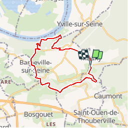
Trail On foot of 12.2 km to be discovered at Normandy, Seine-Maritime, Mauny. This trail is proposed by JMCMoreau.
Description
Randonnée pédestre entre Mauny, Barneville sur Seine et Yville sur Seine. Peu de Bitume.
Positioning
Country:
France
Region :
Normandy
Department/Province :
Seine-Maritime
Municipality :
Mauny
Location:
Unknown
Start:(Dec)
Start:(UTM)
346552 ; 5471868 (31U) N.
Comments