Trail Nordic walking Camiers - La Baie de la Canche depuis Camiers - Photo

La Baie de la Canche depuis Camiers

© OpenStreetMap contributors
Length
Length
6.2 km
Max alt
Max alt
68 m
Uphill gradient
Uphill gradient
96 m
Km-Effort
Km-Effort  
7.4 km
Min alt
Min alt
4 m
Downhill gradient
Downhill gradient
99 m
Boucle
Boucle
Yes
Creation date :
2019-11-14 16:28:53.794
Updated on :
2021-09-30 10:45:39.543

(1 Reviews)

Nordic walking
Nordic walking
1h35
Difficulty : Easy

Scan this QR Code to open this trail in the SityTrail application

FREE GPS app for hiking

Logo SityTrail SityTrail

IGN / Geographical institutes

Download SityTrail from the App Store Download SityTrail from Google Play

Logo SityTrail SityTrail World

The world is yours!

Download SityTrail from the App Store Download SityTrail from Google Play Download SityTrail on Huawei AppGallery

About

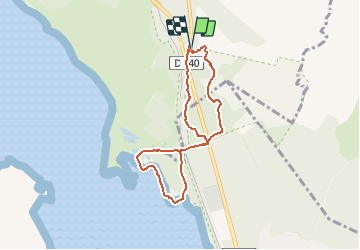
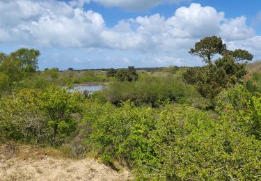
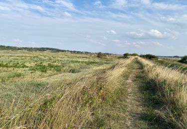
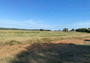
Trail Nordic walking of 6.2 km to be discovered at Hauts-de-France, Pas-de-Calais, Camiers. This trail is proposed by denissculier.

Description

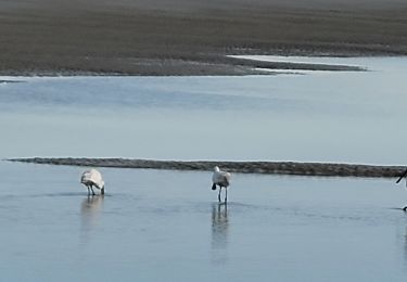
Attention, consulter les marées

Elevation profile

Positioning

Country:
France
Region :
Hauts-de-France
Department/Province :
Pas-de-Calais
Municipality :
Camiers
Location:
Unknown
Start:(UTM)
402179 ; 5600881 (31U) N.

Comments

Please log in to post a review or rate the element


Trails nearby

Trail Cycle Étaples - Les Garnoulles - Etaples - Photo
Cycle
tracegps

Cycle

Medium
(2)
Étaples, Hauts-de-France, Pas-de-Calais, France
34 km | 38 km-effort
2h 45min
Yes
Trail Walking Étaples - Le sentier du Rombly - Etaples - Photo
Walking
tracegps

Walking

Difficult
(3)
Étaples, Hauts-de-France, Pas-de-Calais, France
14.1 km | 17.3 km-effort
3h 30min
Yes
Trail On foot Étaples - Sentier de Rombly - Photo
On foot
PRO

On foot

Medium
Étaples, Hauts-de-France, Pas-de-Calais, France
17.2 km | 21 km-effort
4h 48min
Yes
Trail Walking Camiers - ballade  - Photo
Walking
gregcamb

Walking

Easy
(1)
Camiers, Hauts-de-France, Pas-de-Calais, France
7.8 km | 8.3 km-effort
1h 51min
No
Trail Walking Dannes - Le Mont Saint Frieux - Photo
Walking
tracegps

Walking

Easy
(1)
Dannes, Hauts-de-France, Pas-de-Calais, France
6.1 km | 7.8 km-effort
2h 0min
Yes
Trail Walking Dannes - DANNES MONT SAINT PRIEUX - Photo
Walking
pastoun

Walking

Medium
Dannes, Hauts-de-France, Pas-de-Calais, France
6.4 km | 8 km-effort
2h 16min
Yes
Trail Road bike Le Touquet-Paris-Plage - Le Touquet Vélo  - Photo
Road bike
FOUCAULT

Road bike

Le Touquet-Paris-Plage, Hauts-de-France, Pas-de-Calais, France
23 km | 25 km-effort
2h 24min
Yes
Trail Walking Le Touquet-Paris-Plage - Le Touquet Paris Plage - Photo
Walking
FOUCAULT

Walking

Le Touquet-Paris-Plage, Hauts-de-France, Pas-de-Calais, France
9 km | 9.8 km-effort
2h 36min
No
Trail Nordic walking Le Touquet-Paris-Plage - Marche nordique : Boucle 12 km Le Touquet - Merlimont - Photo
Nordic walking
chessyca

Nordic walking

Very easy
Le Touquet-Paris-Plage, Hauts-de-France, Pas-de-Calais, France
12.3 km | 12.5 km-effort
1h 59min
Yes


Close
My subscriptions