


Eslida col de Barres puntal de l'Aljup Eslida

francisdean
User
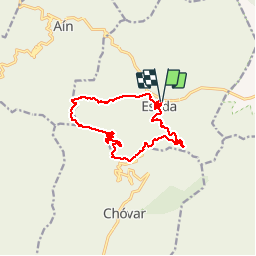

Length
14.4 km

Max alt
936 m

Uphill gradient
657 m
Km-Effort
23 km

Min alt
352 m

Downhill gradient
656 m
Boucle
Yes
Creation date :
2019-11-15 08:13:50.05
Updated on :
2019-11-15 17:36:41.087
6h47
Difficulty : Medium

FREE GPS app for hiking
 SityTrail
IGN / Geographical institutes
SityTrail Plus
The world is yours!
About
Trail Walking of 14.4 km to be discovered at Valencian Community, Castelló / Castellón, Eslida. This trail is proposed by francisdean.
Positioning
Country:
Spain
Region :
Valencian Community
Department/Province :
Castelló / Castellón
Municipality :
Eslida
Location:
Unknown
Start:(Dec)
Start:(UTM)
730278 ; 4417966 (30S) N.
Comments