


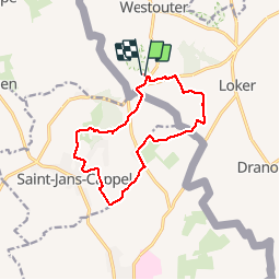
Mont Noir, St Jans Cappel, boucle

reneperrin
User

Length
11.3 km

Max alt
132 m

Uphill gradient
166 m
Km-Effort
13.5 km

Min alt
31 m

Downhill gradient
171 m
Boucle
Yes
Creation date :
2019-11-17 11:37:56.573
Updated on :
2019-11-17 14:16:08.149
2h22
Difficulty : Very easy

FREE GPS app for hiking
 SityTrail
IGN / Geographical institutes
SityTrail Plus
The world is yours!
About
Trail Walking of 11.3 km to be discovered at Flanders, West Flanders, Heuvelland. This trail is proposed by reneperrin.
Description
boucle de 11,3km
Positioning
Country:
Belgium
Region :
Flanders
Department/Province :
West Flanders
Municipality :
Heuvelland
Location:
Westouter
Start:(Dec)
Start:(UTM)
481921 ; 5625889 (31U) N.
Comments