


69 Montanay

trietsch
User
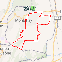

Length
8.8 km

Max alt
310 m

Uphill gradient
158 m
Km-Effort
10.9 km

Min alt
215 m

Downhill gradient
159 m
Boucle
Yes
Creation date :
2019-11-18 09:10:09.299
Updated on :
2019-11-18 09:22:53.755
--
Difficulty : Easy

FREE GPS app for hiking
 SityTrail
IGN / Geographical institutes
SityTrail Plus
The world is yours!
About
Trail On foot of 8.8 km to be discovered at Auvergne-Rhône-Alpes, Métropole de Lyon, Montanay. This trail is proposed by trietsch.
Positioning
Country:
France
Region :
Auvergne-Rhône-Alpes
Department/Province :
Métropole de Lyon
Municipality :
Montanay
Location:
Unknown
Start:(Dec)
Start:(UTM)
644673 ; 5082551 (31T) N.
Comments