


Vercors Tullins / sculptures

c.gourme
User
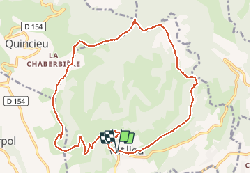

Length
11.9 km

Max alt
780 m

Uphill gradient
453 m
Km-Effort
17.9 km

Min alt
444 m

Downhill gradient
448 m
Boucle
Yes
Creation date :
2019-11-19 09:08:16.0
Updated on :
2020-09-18 12:00:05.417
4h37
Difficulty : Easy

FREE GPS app for hiking
 SityTrail
IGN / Geographical institutes
SityTrail Plus
The world is yours!
About
Trail Walking of 11.9 km to be discovered at Auvergne-Rhône-Alpes, Isère, Vatilieu. This trail is proposed by c.gourme.
Positioning
Country:
France
Region :
Auvergne-Rhône-Alpes
Department/Province :
Isère
Municipality :
Vatilieu
Location:
Unknown
Start:(Dec)
Start:(UTM)
688958 ; 5014237 (31T) N.
Comments