


Côteau Chiron

RobinMicheline
User GUIDE

Length
13 km

Max alt
481 m

Uphill gradient
285 m
Km-Effort
16.8 km

Min alt
401 m

Downhill gradient
286 m
Boucle
Yes
Creation date :
2019-11-19 17:51:10.176
Updated on :
2020-01-07 17:39:40.002
--
Difficulty : Unknown

FREE GPS app for hiking
 SityTrail
IGN / Geographical institutes
SityTrail Plus
The world is yours!
About
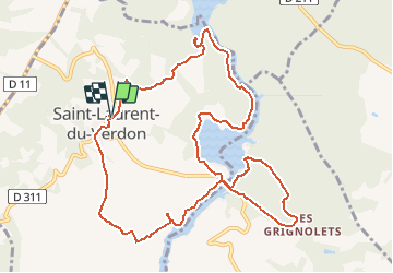
Trail On foot of 13 km to be discovered at Provence-Alpes-Côte d'Azur, Alpes-de-Haute-Provence, Saint-Laurent-du-Verdon. This trail is proposed by RobinMicheline.
Description
Super
Positioning
Country:
France
Region :
Provence-Alpes-Côte d'Azur
Department/Province :
Alpes-de-Haute-Provence
Municipality :
Saint-Laurent-du-Verdon
Location:
Unknown
Start:(Dec)
Start:(UTM)
263935 ; 4845515 (32T) N.
Comments