


Marnans-Les Mermes-2

raymondfn
User
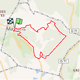

Length
7.6 km

Max alt
620 m

Uphill gradient
228 m
Km-Effort
10.7 km

Min alt
461 m

Downhill gradient
228 m
Boucle
Yes
Creation date :
2019-11-19 18:05:51.436
Updated on :
2019-12-01 17:29:37.719
19m
Difficulty : Easy

FREE GPS app for hiking
 SityTrail
IGN / Geographical institutes
SityTrail Plus
The world is yours!
About
Trail Walking of 7.6 km to be discovered at Auvergne-Rhône-Alpes, Isère, Marnans. This trail is proposed by raymondfn.
Positioning
Country:
France
Region :
Auvergne-Rhône-Alpes
Department/Province :
Isère
Municipality :
Marnans
Location:
Unknown
Start:(Dec)
Start:(UTM)
675320 ; 5018099 (31T) N.
Comments