


chapareillan

Liebeaux
User
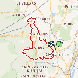

Length
16.6 km

Max alt
970 m

Uphill gradient
775 m
Km-Effort
27 km

Min alt
270 m

Downhill gradient
774 m
Boucle
Yes
Creation date :
2019-11-21 07:46:58.654
Updated on :
2019-11-21 14:36:53.944
6h48
Difficulty : Very easy

FREE GPS app for hiking
 SityTrail
IGN / Geographical institutes
SityTrail Plus
The world is yours!
About
Trail Walking of 16.6 km to be discovered at Auvergne-Rhône-Alpes, Isère, Chapareillan. This trail is proposed by Liebeaux.
Positioning
Country:
France
Region :
Auvergne-Rhône-Alpes
Department/Province :
Isère
Municipality :
Chapareillan
Location:
Unknown
Start:(Dec)
Start:(UTM)
733602 ; 5039028 (31T) N.
Comments