


Lieusaint 22-11-2019

robinier
User
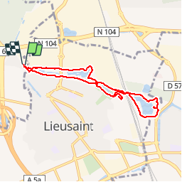

Length
7.1 km

Max alt
92 m

Uphill gradient
46 m
Km-Effort
7.7 km

Min alt
77 m

Downhill gradient
45 m
Boucle
Yes
Creation date :
2019-11-22 13:32:48.0
Updated on :
2019-11-22 15:52:49.153
2h19
Difficulty : Unknown

FREE GPS app for hiking
 SityTrail
IGN / Geographical institutes
SityTrail Plus
The world is yours!
About
Trail Walking of 7.1 km to be discovered at Ile-de-France, Essonne, Tigery. This trail is proposed by robinier.
Positioning
Country:
France
Region :
Ile-de-France
Department/Province :
Essonne
Municipality :
Tigery
Location:
Unknown
Start:(Dec)
Start:(UTM)
466188 ; 5387696 (31U) N.
Comments