


giens NE accès

bernir
User
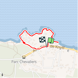

Length
1.5 km

Max alt
18 m

Uphill gradient
20 m
Km-Effort
1.7 km

Min alt
0 m

Downhill gradient
17 m
Boucle
Yes
Creation date :
2019-11-22 15:17:49.017
Updated on :
2019-11-23 09:08:00.751
1h00
Difficulty : Very easy

FREE GPS app for hiking
 SityTrail
IGN / Geographical institutes
SityTrail Plus
The world is yours!
About
Trail Walking of 1.5 km to be discovered at Provence-Alpes-Côte d'Azur, Var, Hyères. This trail is proposed by bernir.
Positioning
Country:
France
Region :
Provence-Alpes-Côte d'Azur
Department/Province :
Var
Municipality :
Hyères
Location:
Unknown
Start:(Dec)
Start:(UTM)
264217 ; 4769347 (32T) N.
Comments