


SityTrail - Cinqueterres 1a

ETMU5496
User
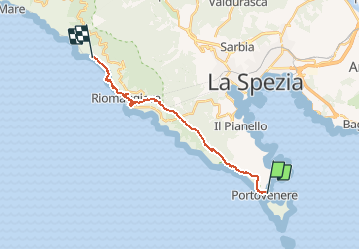

Length
17.2 km

Max alt
576 m

Uphill gradient
895 m
Km-Effort
29 km

Min alt
-4 m

Downhill gradient
881 m
Boucle
No
Creation date :
2019-11-23 12:38:35.099
Updated on :
2019-12-28 16:53:41.513
--
Difficulty : Medium

FREE GPS app for hiking
 SityTrail
IGN / Geographical institutes
SityTrail Plus
The world is yours!
About
Trail On foot of 17.2 km to be discovered at Liguria, La Spezia, Portovenere. This trail is proposed by ETMU5496.
Description
Portovenere-Romagiorre
Positioning
Country:
Italy
Region :
Liguria
Department/Province :
La Spezia
Municipality :
Portovenere
Location:
Unknown
Start:(Dec)
Start:(UTM)
566967 ; 4877938 (32T) N.
Comments