


marathon

oliviergau
User
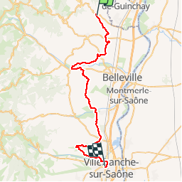

Length
43 km

Max alt
303 m

Uphill gradient
401 m
Km-Effort
48 km

Min alt
178 m

Downhill gradient
517 m
Boucle
No
Creation date :
2019-11-23 08:00:48.939
Updated on :
2019-11-23 12:48:08.55
4h44
Difficulty : Very easy

FREE GPS app for hiking
 SityTrail
IGN / Geographical institutes
SityTrail Plus
The world is yours!
About
Trail Running of 43 km to be discovered at Auvergne-Rhône-Alpes, Rhône, Fleurie. This trail is proposed by oliviergau.
Description
cooirse
Positioning
Country:
France
Region :
Auvergne-Rhône-Alpes
Department/Province :
Rhône
Municipality :
Fleurie
Location:
Unknown
Start:(Dec)
Start:(UTM)
631063 ; 5116827 (31T) N.
Comments