


Amay 10

Steinier
User
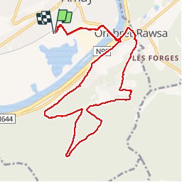

Length
10.3 km

Max alt
218 m

Uphill gradient
186 m
Km-Effort
12.8 km

Min alt
60 m

Downhill gradient
186 m
Boucle
Yes
Creation date :
2019-11-24 10:40:00.0
Updated on :
2019-11-24 12:45:37.281
1h46
Difficulty : Unknown

FREE GPS app for hiking
 SityTrail
IGN / Geographical institutes
SityTrail Plus
The world is yours!
About
Trail Walking of 10.3 km to be discovered at Wallonia, Liège, Amay. This trail is proposed by Steinier.
Positioning
Country:
Belgium
Region :
Wallonia
Department/Province :
Liège
Municipality :
Amay
Location:
Amay
Start:(Dec)
Start:(UTM)
664284 ; 5601722 (31U) N.
Comments