


GR- En Forêt de La Londe

JMCMoreau
User
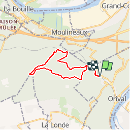

Length
10.6 km

Max alt
124 m

Uphill gradient
220 m
Km-Effort
13.6 km

Min alt
24 m

Downhill gradient
221 m
Boucle
Yes
Creation date :
2019-11-24 16:55:22.626
Updated on :
2019-11-24 16:58:02.375
3h00
Difficulty : Medium

FREE GPS app for hiking
 SityTrail
IGN / Geographical institutes
SityTrail Plus
The world is yours!
About
Trail On foot of 10.6 km to be discovered at Normandy, Seine-Maritime, Orival. This trail is proposed by JMCMoreau.
Description
Rando Proposée par Lionel et Didier
Positioning
Country:
France
Region :
Normandy
Department/Province :
Seine-Maritime
Municipality :
Orival
Location:
Unknown
Start:(Dec)
Start:(UTM)
353603 ; 5465212 (31U) N.
Comments