


St saraille-fonchaude

Dupleix
User
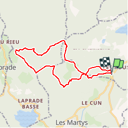

Length
16 km

Max alt
943 m

Uphill gradient
384 m
Km-Effort
21 km

Min alt
797 m

Downhill gradient
383 m
Boucle
Yes
Creation date :
2019-11-25 20:03:09.624
Updated on :
2019-11-25 20:05:38.35
--
Difficulty : Very easy

FREE GPS app for hiking
 SityTrail
IGN / Geographical institutes
SityTrail Plus
The world is yours!
About
Trail On foot of 16 km to be discovered at Occitania, Tarn, Mazamet. This trail is proposed by Dupleix.
Description
Boucle au- dessus du lac des montagnés
Positioning
Country:
France
Region :
Occitania
Department/Province :
Tarn
Municipality :
Mazamet
Location:
Unknown
Start:(Dec)
Start:(UTM)
446080 ; 4809904 (31T) N.
Comments