


bouglainval 10

topophil
User
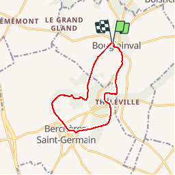

Length
10.8 km

Max alt
178 m

Uphill gradient
129 m
Km-Effort
12.5 km

Min alt
129 m

Downhill gradient
129 m
Boucle
Yes
Creation date :
2019-11-26 13:13:54.919
Updated on :
2019-11-26 15:44:43.859
2h17
Difficulty : Very easy

FREE GPS app for hiking
 SityTrail
IGN / Geographical institutes
SityTrail Plus
The world is yours!
About
Trail Walking of 10.8 km to be discovered at Centre-Loire Valley, Eure-et-Loir, Bouglainval. This trail is proposed by topophil.
Positioning
Country:
France
Region :
Centre-Loire Valley
Department/Province :
Eure-et-Loir
Municipality :
Bouglainval
Location:
Unknown
Start:(Dec)
Start:(UTM)
389722 ; 5380151 (31U) N.
Comments