


chateau de Mison depart Mison village

claude nier
User
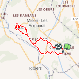

Length
15.5 km

Max alt
660 m

Uphill gradient
280 m
Km-Effort
19.2 km

Min alt
510 m

Downhill gradient
277 m
Boucle
Yes
Creation date :
2019-11-26 08:24:37.789
Updated on :
2019-11-26 16:48:01.76
6h07
Difficulty : Medium

FREE GPS app for hiking
 SityTrail
IGN / Geographical institutes
SityTrail Plus
The world is yours!
About
Trail Walking of 15.5 km to be discovered at Provence-Alpes-Côte d'Azur, Alpes-de-Haute-Provence, Mison. This trail is proposed by claude nier.
Positioning
Country:
France
Region :
Provence-Alpes-Côte d'Azur
Department/Province :
Alpes-de-Haute-Provence
Municipality :
Mison
Location:
Unknown
Start:(Dec)
Start:(UTM)
730634 ; 4902819 (31T) N.
Comments