


2012-02-05T08:01:23Z

jpb83
User
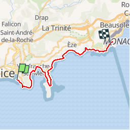

Length
21 km

Max alt
110 m

Uphill gradient
506 m
Km-Effort
28 km

Min alt
0 m

Downhill gradient
495 m
Boucle
No
Creation date :
2019-11-27 09:10:52.278
Updated on :
2019-11-27 09:15:53.01
2h25
Difficulty : Difficult

FREE GPS app for hiking
 SityTrail
IGN / Geographical institutes
SityTrail Plus
The world is yours!
About
Trail Running of 21 km to be discovered at Provence-Alpes-Côte d'Azur, Maritime Alps, Nice. This trail is proposed by jpb83.
Positioning
Country:
France
Region :
Provence-Alpes-Côte d'Azur
Department/Province :
Maritime Alps
Municipality :
Nice
Location:
Unknown
Start:(Dec)
Start:(UTM)
361936 ; 4839359 (32T) N.
Comments