


Villars St Georges

eltonnermou
User
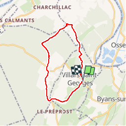

Length
11.7 km

Max alt
302 m

Uphill gradient
198 m
Km-Effort
14.3 km

Min alt
236 m

Downhill gradient
202 m
Boucle
Yes
Creation date :
2019-11-27 12:57:05.191
Updated on :
2019-11-27 15:07:52.677
1h57
Difficulty : Easy

FREE GPS app for hiking
 SityTrail
IGN / Geographical institutes
SityTrail Plus
The world is yours!
About
Trail Walking of 11.7 km to be discovered at Bourgogne-Franche-Comté, Doubs, Villars-Saint-Georges. This trail is proposed by eltonnermou.
Description
randonnée pieds propres (9,5km de goudron).
déambulation agréable à travers vallons et forêts. Randonnée parfaite pour la saison hivernale.
Positioning
Country:
France
Region :
Bourgogne-Franche-Comté
Department/Province :
Doubs
Municipality :
Villars-Saint-Georges
Location:
Unknown
Start:(Dec)
Start:(UTM)
714495 ; 5222894 (31T) N.
Comments