


Les Cagnasses la Fage

ARVIEU
User

Length
22 km

Max alt
916 m

Uphill gradient
782 m
Km-Effort
32 km

Min alt
491 m

Downhill gradient
785 m
Boucle
Yes
Creation date :
2019-11-28 13:15:46.199
Updated on :
2019-11-28 13:19:51.718
5h30
Difficulty : Difficult

FREE GPS app for hiking
 SityTrail
IGN / Geographical institutes
SityTrail Plus
The world is yours!
About
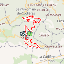
Trail On foot of 22 km to be discovered at Occitania, Gard, Sumène. This trail is proposed by ARVIEU.
Description
Départ de Cezas, puis les Cagnasses, retour Cezas puis la montagne de la Fage.
Positioning
Country:
France
Region :
Occitania
Department/Province :
Gard
Municipality :
Sumène
Location:
Unknown
Start:(Dec)
Start:(UTM)
562482 ; 4869398 (31T) N.
Comments