


roquettes pinsag faot

pidjam
User
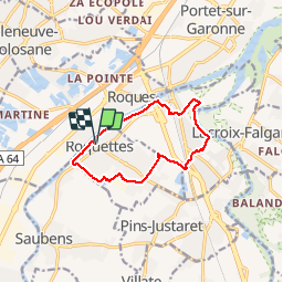

Length
11.1 km

Max alt
167 m

Uphill gradient
86 m
Km-Effort
12.2 km

Min alt
144 m

Downhill gradient
85 m
Boucle
Yes
Creation date :
2019-11-28 12:53:09.726
Updated on :
2019-11-28 15:33:00.74
2h39
Difficulty : Medium

FREE GPS app for hiking
 SityTrail
IGN / Geographical institutes
SityTrail Plus
The world is yours!
About
Trail Walking of 11.1 km to be discovered at Occitania, Haute-Garonne, Roquettes. This trail is proposed by pidjam.
Positioning
Country:
France
Region :
Occitania
Department/Province :
Haute-Garonne
Municipality :
Roquettes
Location:
Unknown
Start:(Dec)
Start:(UTM)
367805 ; 4817643 (31T) N.
Comments