


charrecey

desbois
User
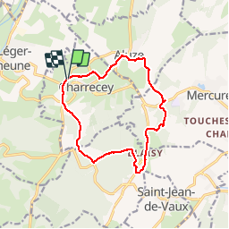

Length
12.8 km

Max alt
426 m

Uphill gradient
309 m
Km-Effort
16.9 km

Min alt
272 m

Downhill gradient
310 m
Boucle
Yes
Creation date :
2019-11-28 12:26:09.218
Updated on :
2019-11-28 15:47:00.078
3h20
Difficulty : Very easy

FREE GPS app for hiking
 SityTrail
IGN / Geographical institutes
SityTrail Plus
The world is yours!
About
Trail Walking of 12.8 km to be discovered at Bourgogne-Franche-Comté, Saône-et-Loire, Charrecey. This trail is proposed by desbois.
Description
12.5km
Positioning
Country:
France
Region :
Bourgogne-Franche-Comté
Department/Province :
Saône-et-Loire
Municipality :
Charrecey
Location:
Unknown
Start:(Dec)
Start:(UTM)
626686 ; 5188792 (31T) N.
Comments