


Giens - Campobario - nov 2019

soca
User
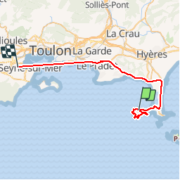

Length
43 km

Max alt
94 m

Uphill gradient
684 m
Km-Effort
52 km

Min alt
-2 m

Downhill gradient
668 m
Boucle
No
Creation date :
2019-11-28 08:31:16.788
Updated on :
2019-11-28 20:57:42.235
4h00
Difficulty : Difficult

FREE GPS app for hiking
 SityTrail
IGN / Geographical institutes
SityTrail Plus
The world is yours!
About
Trail Walking of 43 km to be discovered at Provence-Alpes-Côte d'Azur, Var, Hyères. This trail is proposed by soca.
Positioning
Country:
France
Region :
Provence-Alpes-Côte d'Azur
Department/Province :
Var
Municipality :
Hyères
Location:
Unknown
Start:(Dec)
Start:(UTM)
264090 ; 4769334 (32T) N.
Comments