


randogps62-166

denissculier
User
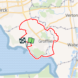

Length
12.4 km

Max alt
18 m

Uphill gradient
48 m
Km-Effort
13 km

Min alt
1 m

Downhill gradient
50 m
Boucle
Yes
Creation date :
2019-11-28 21:40:40.956
Updated on :
2019-11-30 11:36:52.73
2h55
Difficulty : Medium

FREE GPS app for hiking
 SityTrail
IGN / Geographical institutes
SityTrail Plus
The world is yours!
About
Trail Nordic walking of 12.4 km to be discovered at Hauts-de-France, Pas-de-Calais, Groffliers. This trail is proposed by denissculier.
Positioning
Country:
France
Region :
Hauts-de-France
Department/Province :
Pas-de-Calais
Municipality :
Groffliers
Location:
Unknown
Start:(Dec)
Start:(UTM)
400481 ; 5581632 (31U) N.
Comments