Chambaran-Les étangs

raymondfn
User
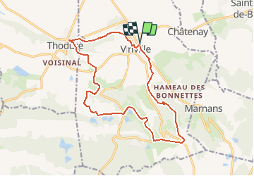

Length
17 km

Max alt
588 m

Uphill gradient
324 m
Km-Effort
21 km

Min alt
313 m

Downhill gradient
325 m
Boucle
Yes
Creation date :
2014-12-10 00:00:00.0
Updated on :
2014-12-10 00:00:00.0
2h50
Difficulty : Medium

FREE GPS app for hiking
 SityTrail
IGN / Geographical institutes
SityTrail Plus
The world is yours!
About
Trail Walking of 17 km to be discovered at Auvergne-Rhône-Alpes, Isère, Viriville. This trail is proposed by raymondfn.
Positioning
Country:
France
Region :
Auvergne-Rhône-Alpes
Department/Province :
Isère
Municipality :
Viriville
Location:
Unknown
Start:(Dec)
Start:(UTM)
672877 ; 5020483 (31T) N.
Comments