


saze/ les sentiers des capitelles

fernandezyvan
User
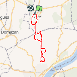

Length
12.8 km

Max alt
166 m

Uphill gradient
294 m
Km-Effort
16.8 km

Min alt
60 m

Downhill gradient
294 m
Boucle
Yes
Creation date :
2019-11-29 08:30:01.708
Updated on :
2019-11-29 15:09:06.706
5h17
Difficulty : Easy

FREE GPS app for hiking
 SityTrail
IGN / Geographical institutes
SityTrail Plus
The world is yours!
About
Trail Walking of 12.8 km to be discovered at Occitania, Gard, Saze. This trail is proposed by fernandezyvan.
Photos

Positioning
Country:
France
Region :
Occitania
Department/Province :
Gard
Municipality :
Saze
Location:
Unknown
Start:(Dec)
Start:(UTM)
634799 ; 4866862 (31T) N.
Comments