


roye

jacthiry
User
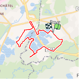

Length
7.7 km

Max alt
300 m

Uphill gradient
47 m
Km-Effort
8.3 km

Min alt
288 m

Downhill gradient
47 m
Boucle
Yes
Creation date :
2019-11-28 12:56:26.492
Updated on :
2019-11-29 17:06:15.947
2h07
Difficulty : Very easy

FREE GPS app for hiking
 SityTrail
IGN / Geographical institutes
SityTrail Plus
The world is yours!
About
Trail Walking of 7.7 km to be discovered at Bourgogne-Franche-Comté, Haute-Saône, Roye. This trail is proposed by jacthiry.
Positioning
Country:
France
Region :
Bourgogne-Franche-Comté
Department/Province :
Haute-Saône
Municipality :
Roye
Location:
Unknown
Start:(Dec)
Start:(UTM)
314765 ; 5282648 (32T) N.
Comments