


La boucle du sailhant

zefreefly
User
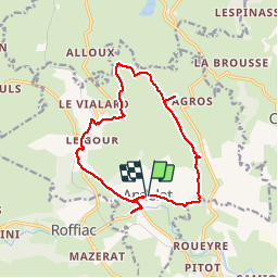

Length
14.3 km

Max alt
1058 m

Uphill gradient
354 m
Km-Effort
19 km

Min alt
797 m

Downhill gradient
351 m
Boucle
Yes
Creation date :
2019-12-01 10:44:16.0
Updated on :
2019-12-01 14:11:13.565
3h24
Difficulty : Medium

FREE GPS app for hiking
 SityTrail
IGN / Geographical institutes
SityTrail Plus
The world is yours!
About
Trail Walking of 14.3 km to be discovered at Auvergne-Rhône-Alpes, Cantal, Andelat. This trail is proposed by zefreefly.
Positioning
Country:
France
Region :
Auvergne-Rhône-Alpes
Department/Province :
Cantal
Municipality :
Andelat
Location:
Unknown
Start:(Dec)
Start:(UTM)
504900 ; 4989591 (31T) N.
Comments