


gleyzette sans boue

pidjam
User
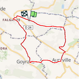

Length
8.6 km

Max alt
267 m

Uphill gradient
197 m
Km-Effort
11.2 km

Min alt
163 m

Downhill gradient
196 m
Boucle
Yes
Creation date :
2019-12-01 13:01:12.277
Updated on :
2019-12-01 14:57:11.712
1h55
Difficulty : Very easy

FREE GPS app for hiking
 SityTrail
IGN / Geographical institutes
SityTrail Plus
The world is yours!
About
Trail Walking of 8.6 km to be discovered at Occitania, Haute-Garonne, Lacroix-Falgarde. This trail is proposed by pidjam.
Positioning
Country:
France
Region :
Occitania
Department/Province :
Haute-Garonne
Municipality :
Lacroix-Falgarde
Location:
Unknown
Start:(Dec)
Start:(UTM)
373473 ; 4817286 (31T) N.
Comments