


Marnans, les Mermes

raymondfn
User
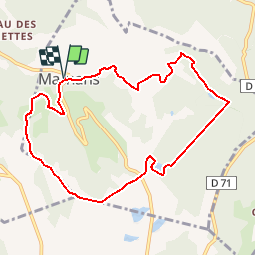

Length
9.2 km

Max alt
620 m

Uphill gradient
233 m
Km-Effort
12.3 km

Min alt
461 m

Downhill gradient
234 m
Boucle
Yes
Creation date :
2014-12-10 00:00:00.0
Updated on :
2019-09-29 18:52:26.449
3h20
Difficulty : Easy

FREE GPS app for hiking
 SityTrail
IGN / Geographical institutes
SityTrail Plus
The world is yours!
About
Trail Walking of 9.2 km to be discovered at Auvergne-Rhône-Alpes, Isère, Marnans. This trail is proposed by raymondfn.
Description
Parking au centre de Marnans, en-dessous de l'abbaye.
Positioning
Country:
France
Region :
Auvergne-Rhône-Alpes
Department/Province :
Isère
Municipality :
Marnans
Location:
Unknown
Start:(Dec)
Start:(UTM)
675320 ; 5018099 (31T) N.
Comments
L'étang des Mermes est effectivement une balade facile. Mon dénivelé Sitytrail indique 382 m.Le tracé est parfait. Super. Merci.Balade de mi saison sans point de vue particulierHGM