


cap de la Lit en boucle

chrisgps
User
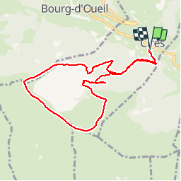

Length
9.9 km

Max alt
1969 m

Uphill gradient
778 m
Km-Effort
20 km

Min alt
1241 m

Downhill gradient
779 m
Boucle
Yes
Creation date :
2019-12-05 08:30:49.14
Updated on :
2019-12-05 18:09:32.037
4h46
Difficulty : Medium

FREE GPS app for hiking
 SityTrail
IGN / Geographical institutes
SityTrail Plus
The world is yours!
About
Trail Walking of 9.9 km to be discovered at Occitania, Haute-Garonne, Cirès. This trail is proposed by chrisgps.
Positioning
Country:
France
Region :
Occitania
Department/Province :
Haute-Garonne
Municipality :
Cirès
Location:
Unknown
Start:(Dec)
Start:(UTM)
297145 ; 4747325 (31T) N.
Comments