


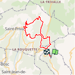
Arboras La Platriere - Les Salces- Pas de l'Azé

philcll
User

Length
18 km

Max alt
753 m

Uphill gradient
808 m
Km-Effort
29 km

Min alt
305 m

Downhill gradient
808 m
Boucle
Yes
Creation date :
2019-12-05 08:28:58.503
Updated on :
2019-12-05 16:05:18.372
5h04
Difficulty : Medium

FREE GPS app for hiking
 SityTrail
IGN / Geographical institutes
SityTrail Plus
The world is yours!
About
Trail Walking of 18 km to be discovered at Occitania, Hérault, Arboras. This trail is proposed by philcll.
Photos

Positioning
Country:
France
Region :
Occitania
Department/Province :
Hérault
Municipality :
Arboras
Location:
Unknown
Start:(Dec)
Start:(UTM)
537683 ; 4841782 (31T) N.
Comments
Très belle randonnée. Par contre, il faut changer le point de départ, par exemple sur le parking du Col du Vent, Les 2 premiers km aller qui sont les mêmes au retour, sont très caillouteux, si à l'aller en montée c'est praticable, par contre au retour avec la fatigue c'est infernal...