


fontaines le lavoir

desbois
User
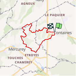

Length
12.4 km

Max alt
364 m

Uphill gradient
279 m
Km-Effort
16.1 km

Min alt
195 m

Downhill gradient
283 m
Boucle
Yes
Creation date :
2019-12-05 12:17:56.191
Updated on :
2019-12-05 15:41:09.313
3h19
Difficulty : Very easy

FREE GPS app for hiking
 SityTrail
IGN / Geographical institutes
SityTrail Plus
The world is yours!
About
Trail Walking of 12.4 km to be discovered at Bourgogne-Franche-Comté, Saône-et-Loire, Fontaines. This trail is proposed by desbois.
Description
12 km
Positioning
Country:
France
Region :
Bourgogne-Franche-Comté
Department/Province :
Saône-et-Loire
Municipality :
Fontaines
Location:
Unknown
Start:(Dec)
Start:(UTM)
634239 ; 5189959 (31T) N.
Comments