


telethon

ymobernard
User
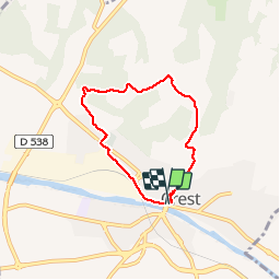

Length
5.6 km

Max alt
315 m

Uphill gradient
142 m
Km-Effort
7.5 km

Min alt
181 m

Downhill gradient
138 m
Boucle
Yes
Creation date :
2019-12-07 12:47:24.516
Updated on :
2019-12-07 14:52:52.513
2h01
Difficulty : Very easy

FREE GPS app for hiking
 SityTrail
IGN / Geographical institutes
SityTrail Plus
The world is yours!
About
Trail Walking of 5.6 km to be discovered at Auvergne-Rhône-Alpes, Drôme, Crest. This trail is proposed by ymobernard.
Positioning
Country:
France
Region :
Auvergne-Rhône-Alpes
Department/Province :
Drôme
Municipality :
Crest
Location:
Unknown
Start:(Dec)
Start:(UTM)
660060 ; 4954685 (31T) N.
Comments