


Serre Tintou - Le Ranc

pb07
User
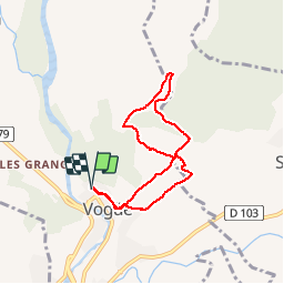

Length
6.7 km

Max alt
272 m

Uphill gradient
122 m
Km-Effort
8.4 km

Min alt
167 m

Downhill gradient
122 m
Boucle
Yes
Creation date :
2019-12-07 14:03:30.797
Updated on :
2019-12-07 16:15:53.002
1h58
Difficulty : Difficult

FREE GPS app for hiking
 SityTrail
IGN / Geographical institutes
SityTrail Plus
The world is yours!
About
Trail Walking of 6.7 km to be discovered at Auvergne-Rhône-Alpes, Ardèche, Vogüé. This trail is proposed by pb07.
Photos


Positioning
Country:
France
Region :
Auvergne-Rhône-Alpes
Department/Province :
Ardèche
Municipality :
Vogüé
Location:
Unknown
Start:(Dec)
Start:(UTM)
612255 ; 4934161 (31T) N.
Comments