


10779393-Poigny le Forêt 18.62

togolo28
User
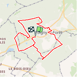

Length
18.6 km

Max alt
182 m

Uphill gradient
241 m
Km-Effort
22 km

Min alt
136 m

Downhill gradient
241 m
Boucle
Yes
Creation date :
2019-12-08 19:18:03.272
Updated on :
2019-12-08 19:19:01.554
--
Difficulty : Medium

FREE GPS app for hiking
 SityTrail
IGN / Geographical institutes
SityTrail Plus
The world is yours!
About
Trail Walking of 18.6 km to be discovered at Ile-de-France, Yvelines, Poigny-la-Forêt. This trail is proposed by togolo28.
Description
Les Rochers d'Angennes
Positioning
Country:
France
Region :
Ile-de-France
Department/Province :
Yvelines
Municipality :
Poigny-la-Forêt
Location:
Unknown
Start:(Dec)
Start:(UTM)
407107 ; 5391847 (31U) N.
Comments