


10779490-St Léger en Yvelines 18.19

togolo28
User
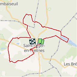

Length
18.2 km

Max alt
193 m

Uphill gradient
223 m
Km-Effort
21 km

Min alt
126 m

Downhill gradient
223 m
Boucle
Yes
Creation date :
2019-12-08 19:19:37.512
Updated on :
2019-12-08 19:20:12.794
--
Difficulty : Medium

FREE GPS app for hiking
 SityTrail
IGN / Geographical institutes
SityTrail Plus
The world is yours!
About
Trail Walking of 18.2 km to be discovered at Ile-de-France, Yvelines, Saint-Léger-en-Yvelines. This trail is proposed by togolo28.
Positioning
Country:
France
Region :
Ile-de-France
Department/Province :
Yvelines
Municipality :
Saint-Léger-en-Yvelines
Location:
Unknown
Start:(Dec)
Start:(UTM)
409297 ; 5397343 (31U) N.
Comments