


Gavarnie Luc St sauveur

ARVIEU
User
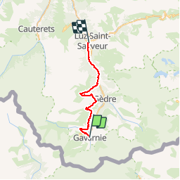

Length
27 km

Max alt
1866 m

Uphill gradient
1063 m
Km-Effort
43 km

Min alt
677 m

Downhill gradient
1758 m
Boucle
No
Creation date :
2019-12-08 21:24:01.112
Updated on :
2019-12-08 21:25:06.801
9h30
Difficulty : Difficult

FREE GPS app for hiking
 SityTrail
IGN / Geographical institutes
SityTrail Plus
The world is yours!
About
Trail On foot of 27 km to be discovered at Occitania, Hautespyrenees, Gavarnie-Gèdre. This trail is proposed by ARVIEU.
Positioning
Country:
France
Region :
Occitania
Department/Province :
Hautespyrenees
Municipality :
Gavarnie-Gèdre
Location:
Gavarnie
Start:(Dec)
Start:(UTM)
744803 ; 4735501 (30T) N.
Comments