Trail Walking Collonges-au-Mont-d'Or - Collonges au mont D'or-Le sentier de l'eau-Rhone - Photo

Collonges au mont D'or-Le sentier de l'eau-Rhone

© OpenStreetMap contributors
Length
Length
4.6 km
Max alt
Max alt
360 m
Uphill gradient
Uphill gradient
133 m
Km-Effort
Km-Effort  
6.4 km
Min alt
Min alt
234 m
Downhill gradient
Downhill gradient
134 m
Boucle
Boucle
Yes
Creation date :
2019-12-08 22:21:23.957
Updated on :
2020-10-18 15:24:29.007

(0 Reviews)

Walking
Walking
1h20
Difficulty : Easy

Scan this QR Code to open this trail in the SityTrail application

FREE GPS app for hiking

Logo SityTrail SityTrail

IGN / Geographical institutes

Download SityTrail from the App Store Download SityTrail from Google Play

Logo SityTrail SityTrail World

The world is yours!

Download SityTrail from the App Store Download SityTrail from Google Play Download SityTrail on Huawei AppGallery

About

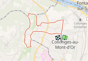
Trail Walking of 4.6 km to be discovered at Auvergne-Rhône-Alpes, Métropole de Lyon, Collonges-au-Mont-d'Or. This trail is proposed by ThierryJ01.

Description

Départ de la mairie. Sentier avec panneaux explicatif.

Elevation profile

Positioning

Country:
France
Region :
Auvergne-Rhône-Alpes
Department/Province :
Métropole de Lyon
Municipality :
Collonges-au-Mont-d'Or
Location:
Unknown
Start:(UTM)
642914 ; 5076066 (31T) N.

Trails nearby

Trail Walking Couzon-au-Mont-d'Or - Tour de Couzon par les crêtes - Photo
Walking
boivin101

Walking

Difficult
(2)
Couzon-au-Mont-d'Or, Auvergne-Rhône-Alpes, Métropole de Lyon, France
6.5 km | 10.7 km-effort
2h 5min
Yes
Trail Mountain bike Collonges-au-Mont-d'Or - Tour du Mont Cindre et Mont Thoux - Photo
Mountain bike
tracegps

Mountain bike

Difficult
(3)
Collonges-au-Mont-d'Or, Auvergne-Rhône-Alpes, Métropole de Lyon, France
25 km | 33 km-effort
1h 40min
Yes
Trail Walking Caluire-et-Cuire - A_CALUIRE 69300 St-Clair - Crépieux - Photo
Walking
ANDREJAC

Walking

Easy
(1)
Caluire-et-Cuire, Auvergne-Rhône-Alpes, Métropole de Lyon, France
10 km | 11.7 km-effort
3h 0min
Yes
Trail Walking Couzon-au-Mont-d'Or - A_COUZON AU MT D'OR 69270  Croix Vitaise - Mont Thoux - Photo
Walking
ANDREJAC

Walking

Medium
(2)
Couzon-au-Mont-d'Or, Auvergne-Rhône-Alpes, Métropole de Lyon, France
8.5 km | 13.6 km-effort
3h 0min
Yes
Trail Mountain bike Lyon - Monts d'Or_02 - Photo
Mountain bike
philmascio

Mountain bike

Medium
(2)
Lyon, Auvergne-Rhône-Alpes, Métropole de Lyon, France
32 km | 45 km-effort
2h 54min
Yes
Trail Mountain bike Fontaines-sur-Saône - Rando de la Madone de Fleurieu sur Saône - Photo
Mountain bike
tracegps

Mountain bike

Medium
(1)
Fontaines-sur-Saône, Auvergne-Rhône-Alpes, Métropole de Lyon, France
24 km | 30 km-effort
2h 30min
Yes
Trail Walking Poleymieux-au-Mont-d'Or - Balade dans les Monts d'Or - Photo
Walking
tracegps

Walking

Medium
(2)
Poleymieux-au-Mont-d'Or, Auvergne-Rhône-Alpes, Métropole de Lyon, France
13.1 km | 19.9 km-effort
3h 0min
Yes
Trail Walking Saint-Cyr-au-Mont-d'Or - s3-c_st_cyr_69450_3d_homme_paysage - Photo
Walking
vidal.galaxy

Walking

Medium
(1)
Saint-Cyr-au-Mont-d'Or, Auvergne-Rhône-Alpes, Métropole de Lyon, France
6.6 km | 9.3 km-effort
2h 6min
Yes
Trail Walking Lyon - cuire et ile barbe - Photo
Walking
maclobar

Walking

Very difficult
Lyon, Auvergne-Rhône-Alpes, Métropole de Lyon, France
17.8 km | 23 km-effort
5h 16min
No


Close
My subscriptions