


Bastille Monceau Bastille 10-12-19

Pascal_M44
User
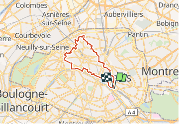

Length
23 km

Max alt
106 m

Uphill gradient
336 m
Km-Effort
28 km

Min alt
21 m

Downhill gradient
338 m
Boucle
Yes
Creation date :
2019-12-10 08:27:31.579
Updated on :
2019-12-10 14:13:53.025
5h44
Difficulty : Easy

FREE GPS app for hiking
 SityTrail
IGN / Geographical institutes
SityTrail Plus
The world is yours!
About
Trail Walking of 23 km to be discovered at Ile-de-France, Paris, Paris. This trail is proposed by Pascal_M44.
Description
Montmartre Batignolles Tuileries quai de Seine
Positioning
Country:
France
Region :
Ile-de-France
Department/Province :
Paris
Municipality :
Paris
Location:
12th Arrondissement
Start:(Dec)
Start:(UTM)
453711 ; 5410581 (31U) N.
Comments