


sanilhac Claudine 10 déc 19

Dan30
User
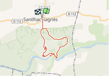

Length
7.3 km

Max alt
179 m

Uphill gradient
218 m
Km-Effort
10.2 km

Min alt
35 m

Downhill gradient
218 m
Boucle
Yes
Creation date :
2019-12-10 12:45:16.103
Updated on :
2019-12-10 15:27:37.553
2h40
Difficulty : Medium

FREE GPS app for hiking
 SityTrail
IGN / Geographical institutes
SityTrail Plus
The world is yours!
About
Trail Walking of 7.3 km to be discovered at Occitania, Gard, Sanilhac-Sagriès. This trail is proposed by Dan30.
Positioning
Country:
France
Region :
Occitania
Department/Province :
Gard
Municipality :
Sanilhac-Sagriès
Location:
Unknown
Start:(Dec)
Start:(UTM)
614351 ; 4867734 (31T) N.
Comments