


20191211 pic cap roux rando réellement

Sugg
User
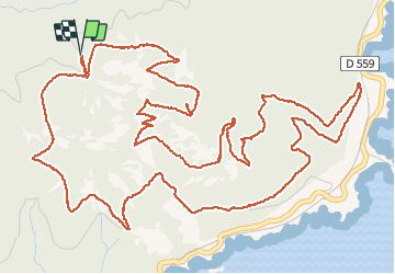

Length
10.7 km

Max alt
440 m

Uphill gradient
543 m
Km-Effort
17.9 km

Min alt
59 m

Downhill gradient
541 m
Boucle
Yes
Creation date :
2019-12-11 08:56:28.704
Updated on :
2019-12-11 14:42:23.712
5h42
Difficulty : Medium

FREE GPS app for hiking
 SityTrail
IGN / Geographical institutes
SityTrail Plus
The world is yours!
About
Trail Walking of 10.7 km to be discovered at Provence-Alpes-Côte d'Azur, Var, Saint-Raphaël. This trail is proposed by Sugg.
Description
rando gr1 RF
Positioning
Country:
France
Region :
Provence-Alpes-Côte d'Azur
Department/Province :
Var
Municipality :
Saint-Raphaël
Location:
Unknown
Start:(Dec)
Start:(UTM)
329919 ; 4813791 (32T) N.
Comments
Une randonnée pendant laquelle on a une vue 90 % du temps : et qu’elle vue ! Terrible Magnifique,merci du partage