


les denis

vincente204
User
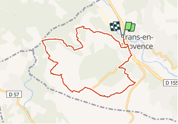

Length
10.5 km

Max alt
252 m

Uphill gradient
247 m
Km-Effort
13.8 km

Min alt
149 m

Downhill gradient
243 m
Boucle
Yes
Creation date :
2019-12-11 12:47:51.134
Updated on :
2019-12-11 15:43:17.795
2h53
Difficulty : Very easy

FREE GPS app for hiking
 SityTrail
IGN / Geographical institutes
SityTrail Plus
The world is yours!
About
Trail Walking of 10.5 km to be discovered at Provence-Alpes-Côte d'Azur, Var, Trans-en-Provence. This trail is proposed by vincente204.
Description
facile
Positioning
Country:
France
Region :
Provence-Alpes-Côte d'Azur
Department/Province :
Var
Municipality :
Trans-en-Provence
Location:
Unknown
Start:(Dec)
Start:(UTM)
296441 ; 4819957 (32T) N.
Comments
bonjour, ce parcours présente 3 interdictions de passage. A Clamatiou le sentier à gauche se termine devant une clôture. En amont côté 215,devant la structure métallique-maison,portail bleu,le propriétaire autorise le passage en prenant sur la gauche le chemin,ce qui permet de reprendre le circuit. A Lamanois cote 209,le chemin à travers les oliviers est fermé par une barrière, continuer et prendre à droite. A la cote 204,le chemin est privé. Nous avons décider de quitter le parcours en continuant la petite route qui mène au GR51 653A. A l'abbaye, retour à Trans par la voie verte,puis un détour par la passerelle. Le circuit représente 17km environ 4h30. Audier.