


theys

Liebeaux
User
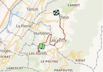

Length
9.2 km

Max alt
1054 m

Uphill gradient
358 m
Km-Effort
14.5 km

Min alt
619 m

Downhill gradient
490 m
Boucle
No
Creation date :
2019-12-12 08:13:32.048
Updated on :
2019-12-12 11:18:26.512
3h04
Difficulty : Very easy

FREE GPS app for hiking
 SityTrail
IGN / Geographical institutes
SityTrail Plus
The world is yours!
About
Trail Walking of 9.2 km to be discovered at Auvergne-Rhône-Alpes, Isère, Les Adrets. This trail is proposed by Liebeaux.
Positioning
Country:
France
Region :
Auvergne-Rhône-Alpes
Department/Province :
Isère
Municipality :
Les Adrets
Location:
Unknown
Start:(Dec)
Start:(UTM)
732547 ; 5017385 (31T) N.
Comments