


giens la madrague_port du niel

bernir
User
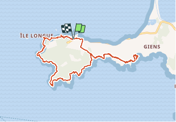

Length
11.3 km

Max alt
109 m

Uphill gradient
389 m
Km-Effort
16.5 km

Min alt
0 m

Downhill gradient
391 m
Boucle
Yes
Creation date :
2019-12-12 09:55:43.394
Updated on :
2019-12-13 16:52:01.572
3h40
Difficulty : Medium

FREE GPS app for hiking
 SityTrail
IGN / Geographical institutes
SityTrail Plus
The world is yours!
About
Trail Walking of 11.3 km to be discovered at Provence-Alpes-Côte d'Azur, Var, Hyères. This trail is proposed by bernir.
Positioning
Country:
France
Region :
Provence-Alpes-Côte d'Azur
Department/Province :
Var
Municipality :
Hyères
Location:
Unknown
Start:(Dec)
Start:(UTM)
264128 ; 4769335 (32T) N.
Comments