


13.12.19 piste

suzanne.bron
User
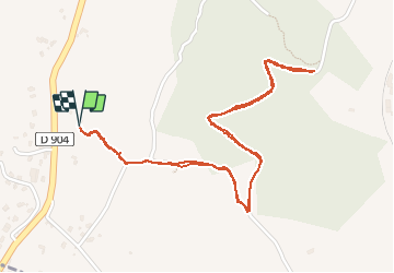

Length
3.1 km

Max alt
280 m

Uphill gradient
98 m
Km-Effort
4.4 km

Min alt
229 m

Downhill gradient
98 m
Boucle
Yes
Creation date :
2019-12-13 08:28:20.16
Updated on :
2019-12-13 09:24:53.346
56m
Difficulty : Very easy

FREE GPS app for hiking
 SityTrail
IGN / Geographical institutes
SityTrail Plus
The world is yours!
About
Trail Walking of 3.1 km to be discovered at Occitania, Gard, Saint-Ambroix. This trail is proposed by suzanne.bron.
Description
Je ne pouvais pas en avant...
Positioning
Country:
France
Region :
Occitania
Department/Province :
Gard
Municipality :
Saint-Ambroix
Location:
Unknown
Start:(Dec)
Start:(UTM)
594401 ; 4900139 (31T) N.
Comments