


Rocher rechandet

ericb25
User
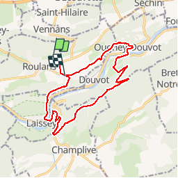

Length
15.9 km

Max alt
566 m

Uphill gradient
478 m
Km-Effort
22 km

Min alt
253 m

Downhill gradient
509 m
Boucle
No
Creation date :
2014-12-10 00:00:00.0
Updated on :
2014-12-10 00:00:00.0
3h36
Difficulty : Difficult

FREE GPS app for hiking
 SityTrail
IGN / Geographical institutes
SityTrail Plus
The world is yours!
About
Trail Walking of 15.9 km to be discovered at Bourgogne-Franche-Comté, Doubs, Roulans. This trail is proposed by ericb25.
Description
de roulans a rechandet
Positioning
Country:
France
Region :
Bourgogne-Franche-Comté
Department/Province :
Doubs
Municipality :
Roulans
Location:
Unknown
Start:(Dec)
Start:(UTM)
291257 ; 5244236 (32T) N.
Comments