


26 Saou, Rochecolombe

DEYGAT
User
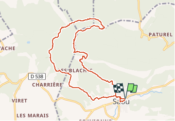

Length
10.5 km

Max alt
874 m

Uphill gradient
587 m
Km-Effort
18.3 km

Min alt
328 m

Downhill gradient
588 m
Boucle
Yes
Creation date :
2019-12-14 16:34:49.052
Updated on :
2019-12-14 16:34:49.052

FREE GPS app for hiking
 SityTrail
IGN / Geographical institutes
SityTrail Plus
The world is yours!
About
Trail of 10.5 km to be discovered at Auvergne-Rhône-Alpes, Drôme, Saou. This trail is proposed by DEYGAT.
Positioning
Country:
France
Region :
Auvergne-Rhône-Alpes
Department/Province :
Drôme
Municipality :
Saou
Location:
Unknown
Start:(Dec)
Start:(UTM)
663694 ; 4945762 (31T) N.
Comments