


RS-SESG-nature et patrimoine

dan48
User
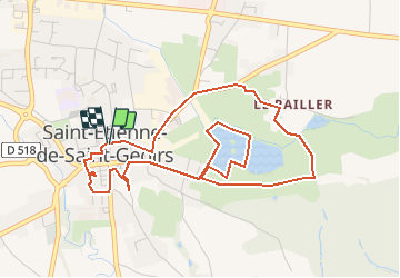

Length
5.4 km

Max alt
415 m

Uphill gradient
52 m
Km-Effort
6 km

Min alt
384 m

Downhill gradient
49 m
Boucle
Yes
Creation date :
2019-12-14 17:00:03.123
Updated on :
2019-12-14 17:03:37.707
1h20
Difficulty : Easy

FREE GPS app for hiking
 SityTrail
IGN / Geographical institutes
SityTrail Plus
The world is yours!
About
Trail Walking of 5.4 km to be discovered at Auvergne-Rhône-Alpes, Isère, Saint-Étienne-de-Saint-Geoirs. This trail is proposed by dan48.
Photos

Positioning
Country:
France
Region :
Auvergne-Rhône-Alpes
Department/Province :
Isère
Municipality :
Saint-Étienne-de-Saint-Geoirs
Location:
Unknown
Start:(Dec)
Start:(UTM)
683680 ; 5023380 (31T) N.
Comments